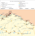
File:Rätischer Donaulimes.png
From Wikimedia Commons, the free media repository
Jump to navigation
Jump to search

Size of this preview: 571 × 599 pixels. Other resolutions: 229 × 240 pixels | 457 × 480 pixels | 731 × 768 pixels | 975 × 1,024 pixels | 1,951 × 2,048 pixels | 4,170 × 4,378 pixels.
Original file (4,170 × 4,378 pixels, file size: 3.18 MB, MIME type: image/png)
File information
Structured data
Captions
Captions
Add a one-line explanation of what this file represents
Summary
[edit]| DescriptionRätischer Donaulimes.png |
Deutsch: Putzger – Historischer Weltatlas, 89. Auflage, 1965; Westermanns Großer Atlas zur Weltgeschichte, 1978; Martin Kemkes: „Römer an Donau und Iller. Neue Forschungen und Funde.“ Thorbecke, Sigmaringen 1996, ISBN 3-7995-0410-9, S. 152f.; Dietwulf Baatz: Der Römische Limes. Archäologische Ausflüge zwischen Rhein und Donau. 4. Auflage. Gebr. Mann, Berlin 2000, ISBN 3-7861-2347-0; Thomas Fischer und Günther Ulbert: Der Limes in Bayern. Von Dinkelsbühl bis Eining. Theiss, Stuttgart 1983 ISBN 3-8062-0351-2; Wolfgang Czysz u.a.: Die Römer in Bayern. Lizenzausgabe. Nikol, Hamburg 2005, ISBN 3-937872-11-6; Dieter Planck u.a.: Imperium Romanum. Roms Provinzen an Neckar, Rhein und Donau. Theiss, Stuttgart 2005. ISBN 978-3-8062-2140-4; Thomas Fischer, Erika Riedmeier-Fischer: Der römische Limes in Bayern. Pustet, Regensburg 2008. ISBN 978-3-7917-2120-0; Daten des bayerischen Landesdenkmalamtes und des österreichischen Bundesdenkmalamtes |
| Date | |
| Source | Own work |
| Author | Mediatus (Karteninhalt, Gestaltung, Präsentation) und ziegelbrenner (Farbe, konzeptionelles Aussehen) |
| Other versions | italienische Version |
|
Do not upload new revisions over this file version without my explicit consent. Instead, use the possibility to upload a new version under a new name and tag it as a derivative or extract of this file. Mediatus |
Licensing
[edit]I, the copyright holder of this work, hereby publish it under the following license:
This file is licensed under the Creative Commons Attribution-Share Alike 3.0 Unported license.
- You are free:
- to share – to copy, distribute and transmit the work
- to remix – to adapt the work
- Under the following conditions:
- attribution – You must give appropriate credit, provide a link to the license, and indicate if changes were made. You may do so in any reasonable manner, but not in any way that suggests the licensor endorses you or your use.
- share alike – If you remix, transform, or build upon the material, you must distribute your contributions under the same or compatible license as the original.
File history
Click on a date/time to view the file as it appeared at that time.
| Date/Time | Thumbnail | Dimensions | User | Comment | |
|---|---|---|---|---|---|
| current | 13:59, 7 November 2018 |  | 4,170 × 4,378 (3.18 MB) | Mediatus (talk | contribs) | Kleinigkeit |
| 13:54, 7 November 2018 |  | 4,170 × 4,378 (3.18 MB) | Mediatus (talk | contribs) | größer | |
| 13:50, 7 November 2018 |  | 1,064 × 1,117 (437 KB) | Mediatus (talk | contribs) | Aying nachgetragen | |
| 14:59, 16 March 2013 |  | 4,844 × 5,085 (3.28 MB) | Mediatus (talk | contribs) | verbessert | |
| 21:55, 11 March 2013 |  | 4,844 × 5,085 (3.28 MB) | Mediatus (talk | contribs) | hat nicht geklappt | |
| 21:53, 11 March 2013 |  | 5,316 × 5,581 (1.65 MB) | Mediatus (talk | contribs) | Ergänzungen | |
| 03:11, 11 March 2013 |  | 4,724 × 4,959 (1.43 MB) | Mediatus (talk | contribs) | {{Information |Description ={{de|1=Putzger – Historischer Weltatlas, 89. Auflage, 1965; Westermanns Großer Atlas zur Weltgeschichte, 1978; Martin Kemkes: „Römer an Donau und Iller. Neue Forschungen und Funde.“ Thorbecke, Sigmaringen 1996, IS... |
You cannot overwrite this file.
File usage on Commons
The following page uses this file:
File usage on other wikis
The following other wikis use this file:
- Usage on bar.wikipedia.org
- Usage on cs.wikipedia.org
- Usage on de.wikipedia.org
- Donaulimes
- Wikipedia:Redaktion Altertum/Römischer Limes
- Kastell Kumpfmühl
- Kleinkastell Weltenburg-Frauenberg
- Kastelle von Straubing
- Benutzer:Mediatus/Bilder
- Kastell Künzing
- Kleinkastell Pfatter
- Kastell Batavis
- Kastell Boiodurum
- Römisches Militärlager Ingolstadt-Zuchering (Kastell I)
- Römische Militärlager Ingolstadt-Zuchering (temporäre Lager II und III)
- Kleinkastell Großprüfening
- Benutzer:Ziegelbrenner/Meine Bilder auf Commons
- Burgus Untersaal
- Kleinkastell Alkofen
- Kastell Oberstimm
- Pons Aeni
- Burgus Thaldorf
- Kastell Aying
- Kleinkastell Steinkirchen
- Kleinkastell Weltenburg-Galget
- Kleinkastell Osterhofen-Haardorf
- Kastell Moos-Burgstall
- Benutzer:Drekamu/Antike Geographie
- St. Johann Baptist und Michael (Egmating)
- Usage on fr.wikipedia.org
- Usage on he.wikipedia.org
- Usage on la.wikipedia.org
- Usage on nl.wikipedia.org
- Usage on no.wikipedia.org
- Usage on www.wikidata.org
Hidden categories:
