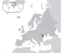
File:Location Moldova Europe.png
From Wikimedia Commons, the free media repository
Jump to navigation
Jump to search

Size of this preview: 685 × 600 pixels. Other resolutions: 274 × 240 pixels | 548 × 480 pixels | 877 × 768 pixels | 1,170 × 1,024 pixels | 2,056 × 1,800 pixels.
Original file (2,056 × 1,800 pixels, file size: 422 KB, MIME type: image/png)
File information
Structured data
Captions
Captions
Add a one-line explanation of what this file represents
Carte de l'Europe avec la Moldavie en vert.
Summary
[edit]| DescriptionLocation Moldova Europe.png |
English: Moldova (green) / Transnistria (light green) / Europe (all green & dark grey); inspired by and consistent with general country locator maps by User:Vardion, et al |
| Date | |
| Source | Own work |
| Author | Bosonic dressing |

|
This map image could be re-created using vector graphics as an SVG file. This has several advantages; see Commons:Media for cleanup for more information. If an SVG form of this image is available, please upload it and afterwards replace this template with
{{vector version available|new image name}}.
It is recommended to name the SVG file “Location Moldova Europe.svg”—then the template Vector version available (or Vva) does not need the new image name parameter. |
Licensing
[edit]| Public domainPublic domainfalsefalse |
| I, the copyright holder of this work, release this work into the public domain. This applies worldwide. In some countries this may not be legally possible; if so: I grant anyone the right to use this work for any purpose, without any conditions, unless such conditions are required by law. |
File history
Click on a date/time to view the file as it appeared at that time.
| Date/Time | Thumbnail | Dimensions | User | Comment | |
|---|---|---|---|---|---|
| current | 09:58, 22 May 2021 |  | 2,056 × 1,800 (422 KB) | Lupishor (talk | contribs) | Reverted to version as of 23:13, 11 July 2020 (UTC) Map is wrong, showing a part of Ukraine as part of Moldova |
| 18:10, 19 May 2021 |  | 2,056 × 1,800 (327 KB) | Yesua Rafael Jara Alcivar (talk | contribs) | Reverted to version as of 01:27, 19 May 2021 (UTC) | |
| 01:27, 19 May 2021 |  | 2,056 × 1,800 (426 KB) | Yesua Rafael Jara Alcivar (talk | contribs) | Reverted to version as of 01:20, 19 May 2021 (UTC) | |
| 01:27, 19 May 2021 |  | 2,056 × 1,800 (327 KB) | Yesua Rafael Jara Alcivar (talk | contribs) | Agregando sus verdaderos territorios | |
| 01:20, 19 May 2021 |  | 2,056 × 1,800 (426 KB) | Yesua Rafael Jara Alcivar (talk | contribs) | Añadiendo territorios que le pertenecen | |
| 23:13, 11 July 2020 |  | 2,056 × 1,800 (422 KB) | De728631 (talk | contribs) | added South Sudan to World map | |
| 15:57, 22 February 2010 |  | 2,056 × 1,800 (355 KB) | Dinamik (talk | contribs) | colors | |
| 23:34, 17 June 2009 |  | 2,056 × 1,800 (365 KB) | Bosonic dressing (talk | contribs) | {{Information |Description={{en|1=Moldova (green) / Transnistria (light green) / Europe (all green & dark grey); inspired by and consistent with general country locator maps by User:Vardion, et al}} |Source=Own work by uploader |Author=[[User:Bosonic dres |
You cannot overwrite this file.
File usage on Commons
The following 3 pages use this file:
File usage on other wikis
The following other wikis use this file:
- Usage on af.wikipedia.org
- Usage on af.wiktionary.org
- Usage on ami.wikipedia.org
- Usage on an.wikipedia.org
- Usage on ar.wikipedia.org
- Usage on ary.wikipedia.org
- Usage on arz.wikipedia.org
- Usage on ast.wikipedia.org
- Usage on avk.wikipedia.org
- Usage on awa.wikipedia.org
- Usage on azb.wikipedia.org
- Usage on az.wikipedia.org
- Usage on az.wiktionary.org
- Usage on ban.wikipedia.org
- Usage on ba.wikipedia.org
- Usage on be-tarask.wikipedia.org
- Usage on be.wikipedia.org
- Usage on bew.wikipedia.org
- Usage on bh.wikipedia.org
- Usage on bi.wikipedia.org
- Usage on bn.wikipedia.org
- Usage on bo.wikipedia.org
- Usage on bs.wikipedia.org
- Usage on bxr.wikipedia.org
- Usage on ca.wikipedia.org
- Usage on cbk-zam.wikipedia.org
- Usage on ce.wikipedia.org
- Usage on chr.wikipedia.org
- Usage on ckb.wikipedia.org
- Usage on csb.wikipedia.org
- Usage on cs.wikipedia.org
- Usage on cv.wikipedia.org
- Usage on cy.wikipedia.org
- Usage on de.wikipedia.org
- Usage on diq.wikipedia.org
- Usage on dty.wikipedia.org
- Usage on dv.wikipedia.org
- Usage on el.wikipedia.org
View more global usage of this file.
Metadata
This file contains additional information such as Exif metadata which may have been added by the digital camera, scanner, or software program used to create or digitize it. If the file has been modified from its original state, some details such as the timestamp may not fully reflect those of the original file. The timestamp is only as accurate as the clock in the camera, and it may be completely wrong.
| Horizontal resolution | 37.79 dpc |
|---|---|
| Vertical resolution | 37.79 dpc |