File:Karte Hilsmulde A - Sackmulde B.png
From Wikimedia Commons, the free media repository
Jump to navigation
Jump to search
Karte_Hilsmulde_A_-_Sackmulde_B.png (530 × 531 pixels, file size: 629 KB, MIME type: image/png)
File information
Structured data
Captions
Captions
Add a one-line explanation of what this file represents
| DescriptionKarte Hilsmulde A - Sackmulde B.png |
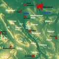
Deutsch: Weser-Leine-Bergland: Reliefkarte der Gegend um Alfeld (Bildmitte) an der Leine, Niedersachsen, Deutschland. Die Karte ist genordet. – A kennzeichnet die Hilsmulde, B die Sackmulde (mit den Sieben Bergen, den Vorbergen und dem Sackwald). |
||
| Date | |||
| Source |
English: relief map from maps-for-free.com including 2 layers "waterbodies" and "admin areas" – slightly reworked (names added etc.) |
||
| Author | Maps for Free (cropped/reworked by bdk) | ||
| Permission (Reusing this file) |
|
||
| Other versions |
|
File history
Click on a date/time to view the file as it appeared at that time.
| Date/Time | Thumbnail | Dimensions | User | Comment | |
|---|---|---|---|---|---|
| current | 15:26, 11 February 2010 |  | 530 × 531 (629 KB) | Bdk (talk | contribs) | +names |
| 15:14, 11 February 2010 |  | 530 × 531 (632 KB) | Bdk (talk | contribs) | {{Information |Description={{de|Weser-Leine-Bergland: Reliefkarte der Gegend um Alfeld (Bildmitte) an der Leine, Niedersachsen, Deutschland. Die Karte ist genordet. – '''A''' kennzeichnet die Hilsmulde, '''B''' die de:Sackmulde.}} |So |
You cannot overwrite this file.
File usage on Commons
The following 3 pages use this file:
File usage on other wikis
The following other wikis use this file:
- Usage on arz.wikipedia.org
- Usage on de.wikipedia.org
- Usage on en.wikipedia.org
- Usage on www.wikidata.org


