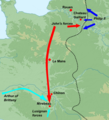
File:1202 French campaign.png
1202_French_campaign.png (528 × 573 pixels, file size: 407 KB, MIME type: image/png)
Captions
Captions

|
This military map image could be re-created using vector graphics as an SVG file. This has several advantages; see Commons:Media for cleanup for more information. If an SVG form of this image is available, please upload it and afterwards replace this template with
{{vector version available|new image name}}.
It is recommended to name the SVG file “1202 French campaign.svg”—then the template Vector version available (or Vva) does not need the new image name parameter. |
Summary
[edit]| Description1202 French campaign.png |
English: French campaign of 1202 overlaid on a blank topographic map of France in the official Lambert-93 projection. Note: The background map is a raster image embedded in the SVG file. Français : Carte topographique vierge de la France suivant la projection officielle Lambert-93. Note : Le fond de carte est une image bitmap embarquée dans le fichier SVG. Lambert-93 projection ; RGF-93 datum Scales: *Topography: 1:2,490,000 (precision 623 m) *Bathymetry: 1:7,640,000 (precision 1,910 m) |
| Date | (UTC) |
| Source |
Own work using:
|
| Author |
|
| This is a retouched picture, which means that it has been digitally altered from its original version. Modifications: French campaign of 1202 added, picture trimmed. The original can be viewed here: France map Lambert-93 topographic-blank.svg:
|
- You are free:
- to share – to copy, distribute and transmit the work
- to remix – to adapt the work
- Under the following conditions:
- attribution – You must give appropriate credit, provide a link to the license, and indicate if changes were made. You may do so in any reasonable manner, but not in any way that suggests the licensor endorses you or your use.
- share alike – If you remix, transform, or build upon the material, you must distribute your contributions under the same or compatible license as the original.

|
Permission is granted to copy, distribute and/or modify this document under the terms of the GNU Free Documentation License, Version 1.2 or any later version published by the Free Software Foundation; with no Invariant Sections, no Front-Cover Texts, and no Back-Cover Texts. A copy of the license is included in the section entitled GNU Free Documentation License.http://www.gnu.org/copyleft/fdl.htmlGFDLGNU Free Documentation Licensetruetrue |
Original upload log
[edit]This image is a derivative work of the following images:
- File:France_map_Lambert-93_topographic-blank.svg licensed with Cc-by-sa-3.0,2.5,2.0,1.0, GFDL
- 2008-11-13T17:24:53Z Sting 2000x1898 (1639447 Bytes) + boundary for Channel Islands ; - canals
- 2008-10-01T04:59:44Z Sting 2000x1898 (1682809 Bytes) == Summary == {{Location|46|15|00|N|02|06|00|E|scale:10000000}} {{Information |Description={{en|Blank topographic map of [[:en:France|France]] in the official Lambert-93 projection.}} {{fr|Carte topographique vierge de la [[
Uploaded with derivativeFX
File history
Click on a date/time to view the file as it appeared at that time.
| Date/Time | Thumbnail | Dimensions | User | Comment | |
|---|---|---|---|---|---|
| current | 17:21, 15 January 2011 |  | 528 × 573 (407 KB) | Hchc2009 (talk | contribs) | Adjustment on eastern border line |
| 00:25, 2 January 2011 |  | 533 × 585 (420 KB) | Hchc2009 (talk | contribs) | {{Information |Description={{en|French campaign of 1202 overlaid on a blank topographic map of France in the official Lambert-93 projection. Information from Warren, "King John", p.78.<br/>''Note:'' The background map is a raster image embe |
You cannot overwrite this file.
File usage on Commons
There are no pages that use this file.
File usage on other wikis
The following other wikis use this file:
- Usage on ca.wikipedia.org
- Usage on de.wikipedia.org
- Usage on en.wikipedia.org
- Usage on es.wikipedia.org
- Usage on fr.wikipedia.org
- Usage on gl.wikipedia.org
- Usage on hu.wikipedia.org
- Usage on ja.wikipedia.org
- Usage on nl.wikipedia.org
- Usage on pt.wikipedia.org
- Usage on ru.wikipedia.org
- Usage on vi.wikipedia.org
- Usage on www.wikidata.org
- Usage on zh.wikipedia.org
Metadata
This file contains additional information such as Exif metadata which may have been added by the digital camera, scanner, or software program used to create or digitize it. If the file has been modified from its original state, some details such as the timestamp may not fully reflect those of the original file. The timestamp is only as accurate as the clock in the camera, and it may be completely wrong.
| Horizontal resolution | 35.43 dpc |
|---|---|
| Vertical resolution | 35.43 dpc |
