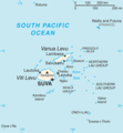
File:Fiji map.png
Appearance
Fiji_map.png (324 × 349 pixels, file size: 11 KB, MIME type: image/png)
File history
Click on a date/time to view the file as it appeared at that time.
| Date/Time | Thumbnail | Dimensions | User | Comment | |
|---|---|---|---|---|---|
| current | 13:26, 1 May 2013 |  | 324 × 349 (11 KB) | Ras67 | cropped |
| 17:14, 16 September 2012 |  | 328 × 353 (23 KB) | Thricecube | Updated version | |
| 17:33, 26 June 2012 |  | 326 × 351 (4 KB) | Ras67 | cropped | |
| 03:18, 12 March 2005 |  | 330 × 355 (4 KB) | Alexander Ilnitsky~commonswiki | Map of Fiji |
File usage
The following 20 pages use this file:
- Cikobia-i-Lau
- Cikobia-i-Ra
- Fiji
- January 2012 Fiji floods
- Koro Island
- Lahloo (clipper)
- Lautoka
- List of birds of Fiji
- List of twin towns and sister cities in Fiji
- Lomaiviti Islands
- Moala Island
- Nadroga-Navosa Province
- Naval Base Fiji
- Rotuma
- Suva
- Vanua Levu
- Vatulele
- Viti Levu
- User:D3adman5225/sandbox
- User:JJ.SS123.123.123/sandbox
Global file usage
The following other wikis use this file:
- Usage on af.wikipedia.org
- Usage on als.wikipedia.org
- Usage on am.wikipedia.org
- Usage on ang.wikipedia.org
- Usage on ar.wikipedia.org
- Usage on arz.wikipedia.org
- Usage on ast.wikipedia.org
- Usage on azb.wikipedia.org
- Usage on az.wikipedia.org
- Usage on ban.wikipedia.org
- Usage on ba.wikipedia.org
- Usage on bcl.wikipedia.org
- Usage on be-tarask.wikipedia.org
- Usage on bn.wikipedia.org
- Usage on br.wikipedia.org
- Usage on ca.wikipedia.org
- Usage on ceb.wikipedia.org
- Usage on cs.wikipedia.org
- Usage on de.wikipedia.org
- Usage on dsb.wikipedia.org
- Usage on el.wikipedia.org
- Usage on en.wikibooks.org
- Usage on en.wikiversity.org
- Usage on eo.wikipedia.org
View more global usage of this file.


