พอร์ตสมัท
หน้าตา
(เปลี่ยนทางจาก Portsmouth)
พอร์ตสมัท | |
|---|---|
City and Unitary Authority Area | |
| City of Portsmouth | |
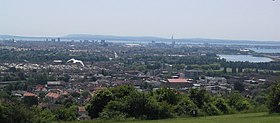
 Portsmouth Skyline viewed from Portsdown Hill | |
| สมญา: Pompey | |
 Location within Hampshire | |
| Sovereign state | United Kingdom |
| Constituent country | England |
| Region | South East England |
| Ceremonial county | Hampshire |
| Admin HQ | Portsmouth City Centre |
| การปกครอง | |
| • ประเภท | Unitary authority, City |
| • Governing body | Portsmouth City Council |
| • Leadership | Leader & Cabinet |
| พื้นที่ | |
| • City and Unitary Authority Area | 15.54 ตร.ไมล์ (40.25 ตร.กม.) |
| ประชากร (2010 est.) | |
| • City and Unitary Authority Area | ([[List of English districts by population|Ranked แม่แบบ:EnglishDistrictRank]] 79th) คน |
| • เขตเมือง | 442,252 คน |
| • รวมปริมณฑล | 1,547,000 คน |
| • Ethnicity (United Kingdom Census 2006 Estimate)[1] | 91.4% White 3.6% S.Asian 1.2% Black 1.3% Mixed 2.5% Chinese and other |
| เขตเวลา | UTC0 (GMT) |
| • ฤดูร้อน (เวลาออมแสง) | UTC+1 (BST) |
| เว็บไซต์ | Portsmouth City Council |
พอร์ตสมัท (อังกฤษ: Portsmouth) เป็นเมืองใหญ่อันดับ 2 ของแฮมป์เชอร์เคาน์ตี ทางชายฝั่งตอนใต้ของอังกฤษ เป็นเมืองเกาะแห่งเดียวในสหราชอาณาจักร ตั้งอยู่บนเกาะพอร์ตซี ในช่องแคบอังกฤษ[2] อยู่ห่างจากกรุงลอนดอนทางทิศตะวันตกเฉียงใต้ราว 103 กม. และอยู่ห่างจากเมืองเซาแทมป์ตันทางทิศตะวันออกเฉียงใต้ 31 กม. มีฐานทัพเรือที่สำคัญที่สร้างมานานหลายศตวรรษ ในระหว่างสงครามโลกครั้งที่สอง ได้รับความเสียหายอย่างมากจากการทิ้งระเบิดของเยอรมนี
พอร์ตสมัทมีประชากร 207,100 คน และเป็นเมืองเดียวในอังกฤษที่มีความหนาแน่นประชากร (4,639 /กม2 (12,010 ตร.ไมล์)) มากกว่ากรุงลอนดอน (4,562 /กม2 (11,820 /ตร.ไมล์))
อ้างอิง
[แก้]- ↑ "Neighbourhood Statistics".
- ↑ Fox, Kieran (13 May 2008). "England | Hampshire | Pompey buck unfashionable trend". BBC News. สืบค้นเมื่อ 7 May 2009.


