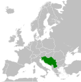
Датотека:Yugoslavia 1956-1990.svg

Величина PNG прегледа за ову SVG датотеку је 450 × 456 пиксела. 5 других резолуција: 237 × 240 пиксела | 474 × 480 пиксела | 758 × 768 пиксела | 1.011 × 1.024 пиксела | 2.021 × 2.048 пиксела.
Оригинална датотека (SVG датотека, номинално 450 × 456 пиксела, величина: 475 kB)
Историја датотеке
Кликните на датум/време да бисте видели тадашњу верзију датотеке.
| Датум/време | Минијатура | Димензије | Корисник | Коментар | |
|---|---|---|---|---|---|
| тренутна | 02:00, 26. новембар 2011. |  | 450 × 456 (475 kB) | StalwartUK | == {{int:filedesc}} == {{Information |Description={{en|Map of Socialist Federal Republic of Yugoslavia as it was from 1945-1992. Surrounding countries accurate from 1956-1990.}} |Source=*[[:File:Blank_map_o |
Употреба датотеке
2 следеће странице користе ову датотеку:
Глобална употреба датотеке
Други викији који користе ову датотеку:
- Употреба на ar.wikipedia.org
- Употреба на arz.wikipedia.org
- Употреба на ast.wikipedia.org
- Употреба на ast.wiktionary.org
- Употреба на azb.wikipedia.org
- Употреба на az.wikipedia.org
- Употреба на az.wiktionary.org
- Употреба на be-tarask.wikipedia.org
- Употреба на be.wikipedia.org
- Употреба на bg.wikipedia.org
- Употреба на bs.wikipedia.org
- Употреба на ca.wikipedia.org
- Употреба на ce.wikipedia.org
- Употреба на cs.wikipedia.org
- Употреба на da.wikipedia.org
- Употреба на de.wikipedia.org
- Употреба на en.wikipedia.org
- Socialist Federal Republic of Yugoslavia
- User:Mr Hall of England/sandbox
- Telephone numbers in Yugoslavia
- Soviet involvement in regime change
- User:XP6287/sandbox
- Guyana–Yugoslavia relations
- Cyprus–Yugoslavia relations
- Afghanistan–Yugoslavia relations
- Pakistan–Yugoslavia relations
- Canada–Yugoslavia relations
- Malta–Yugoslavia relations
- Germany–Yugoslavia relations
- Nicaragua–Yugoslavia relations
- Brazil–Yugoslavia relations
- Cambodia–Yugoslavia relations
- List of companies of the Socialist Federal Republic of Yugoslavia
- User:Falcaorib/Serbia, Yugoslavia and Albania
- Употреба на en.wiktionary.org
- Употреба на es.wikipedia.org
- Употреба на es.wiktionary.org
- Употреба на eu.wikipedia.org
- Употреба на fa.wikipedia.org
- Употреба на fi.wikipedia.org
- Употреба на fo.wikipedia.org
- Употреба на frr.wikipedia.org
- Употреба на fr.wikipedia.org
- Употреба на gl.wikipedia.org
- Употреба на gv.wikipedia.org
Још глобалног коришћења ове датотеке.


