Vaasa
Vaasa (Swadish: Vasa) is a ceety on the wast coast o Finland.
Vaasa Vaasa – Vasa | |
|---|---|
Ceety | |
| Vaasan kaupunki Vasa stad | |
 | |
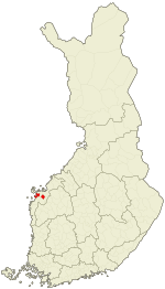
 Location o Vaasa in Finland | |
| Coordinates: 63°06′N 021°37′E / 63.100°N 21.617°ECoordinates: 63°06′N 021°37′E / 63.100°N 21.617°E | |
| Kintra | |
| Region | Ostrobothnia (Finnish: Pohjanmaa) (Swadish: Österbotten) |
| Sub-region | Vaasa sub-region |
| Charter | 1606 |
| Govrenment | |
| • Ceety manager | Tomas Häyry |
| Area (2018-01-01)[1] | |
| • Ceety | 545.14 km2 (210.48 sq mi) |
| • Laund | 188.81 km2 (72.90 sq mi) |
| • Water | 208.63 km2 (80.55 sq mi) |
| • Urban | 66.65 km2 (25.73 sq mi) |
| Area rank | 210t lairgest in Finland |
| Population (2023-02-28)[2] | |
| • Ceety | 68,049 |
| • Rank | 15t lairgest in Finland |
| • Density | 360.41/km2 (933.5/sq mi) |
| • Urban | 65,414 |
| • Urban density | 981.5/km2 (2,542/sq mi) |
| Population bi native leid | |
| • Finnish | 69.8% (offeecial) |
| • Swadish | 24.8% (offeecial) |
| • Ithers | 5.4% |
| Population by age | |
| • 0 tae 14 | 16% |
| • 15 tae 64 | 67.4% |
| • 65 or aulder | 16.7% |
| Time zone | UTC+2 (EET) |
| • Summer (DST) | UTC+3 (EEST) |
| Website | www.vaasa.fi |
References
eedit- ↑ "Area of Finnish Municipalities 1.1.2018" (PDF). National Land Survey of Finland. Retrieved 30 Januar 2018.
- ↑ "Preliminar population structur bi aurie, 2022M01*-2023M02*". StatFin (in Finnish). Statistics Finland. Retrieved 4 Apryle 2023.
- ↑ "Population according to language and the number of foreigners and land area km2 by area as of 31 December 2008". Statistics Finland's PX-Web databases. Statistics Finland. Retrieved 29 Mairch 2009.
- ↑ "Population according to age and gender by area as of 31 December 2008". Statistics Finland's PX-Web databases. Statistics Finland. Retrieved 28 Apryle 2009.
- ↑ a b "Luettelo kuntien ja seurakuntien tuloveroprosenteista vuonna 2023". Tax Admeenistration o Finland. 14 November 2022. Retrieved 7 Mey 2023.
| Wikimedia Commons haes media relatit tae Vaasa. |

