Vai al contenuto

File:Cameroon boundary changes-de.svg

Contenuti della pagina non supportati in altre lingue.
File proveniente da Wikimedia Commons. Clicca per visitare la pagina originale
Da Wikipedia, l'enciclopedia libera.

File originale (file in formato SVG, dimensioni nominali 1 002 × 904 pixel, dimensione del file: 559 KB)

Logo di Commons
Logo di Commons
Questo file e la sua pagina di descrizione (discussione · modifica) si trovano su Wikimedia Commons (?)

Dettagli

Descrizione
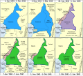
Deutsch: Änderung des Grenzverlaufs von Kamerun.
English: Boundary changes in Cameroon.
Français : Évolution des frontières du Cameroun entre 1901 et 1962
Italiano: Evoluzione delle frontiere del Camerun tra il 1901 ed il 1962


Deutsch: Die deutsche Kolonie Kamerun – Seit 1884 Protektorat, Deutsch-Westafrika bis 1891, Deutsch-Nordwestafrika bis 1901, danach in Kamerun umbenannt. Ebenso das von Frankreich am 4.Nov. 1911 nach der Zweiten Marokkokrise abgetretene Territorium, das zu Neukamerun wurde, während ein kleiner Teil des Gebiets östlich des Flusses Logone (heute im Tschad) von Kamerun an Französisch-Äquatorialafrika abgegeben wurde. Invasion der Entente 1914 während des 1. Weltkriegs, Kapitulation der deutschen Truppen in Kamerun am 4. März 1916, Besetzung durch die Entente, danach formell Mandatsgebiet des Völkerbundes am 28. Juni 1919.
English: German colony of Kamerun – Protectorate from 1884, German West Africa until 1891, German North-west Africa until 1901, when renamed Kamerun. Ceded territory by France on 4 Nov. 1911 following the Agadir Crisis which becomes Neukamerun, while a small amount of territory east of the Logone River (now Chad) was ceded to French Equatorial Africa from Kamerun. Invaded by the allies in 1914 during WWI, final surrender of Germans in Cameroon 4 Mar 1916, occupied by allies, formally becomes League of Nations Mandates 28 Jun, 1919.
Français : Colonie allemande du Cameroun
Italiano: Camerun tedesco


Deutsch: Cameroons – Britisches Mandatsgebiet des Völkerbundes von 1919 (geteilt in Northern Cameroons und Southern Cameroons. Northern Cameroons bestand aus zwei von einander getrennten Teilen und wurde als Territorium von Nigeria verwaltet. Southern Cameroons zählte als eigenständige Provinz Nigerias. Nach dem 13 Dezember 1946 Treuhandgebiet der UNO. Wurde am 1. Oktober 1954 ein autonomer Teil Nigerias. Northern Cameroons schloß sich am 1. Juni 1961 Nigeria an. Southern Cameroons wurde am 1. Oktober 1961 ein Teil Kameruns.
English: British Cameroons – League of Nations mandate from 1919 (divided into separate Northern Cameroons and Southern Cameroons. Northern Cameroons consisted of two non-contiguous sections. Northern Cameroons administered as territory of Nigeria, Southern Cameroons as a separate province of Nigeria. UN trust territory after 13 Dec 1946. Becomes an autonomous part of the colony of Nigeria, 1 Oct 1954. Northern Cameroons joins Nigeria 1 Jun 1961. Southern Cameroons becomes part of Cameroon, 1 Oct. 1961.
Français : Cameroun britannique
Italiano: Camerun britannico


Deutsch: Französisch-Kamerun – Ursprünglich ein Völkerbundsmandat von 1919, wurde UNO-Treuhandgebiet am 13. Dezember 1946.
English: French Cameroun – Originally League of Nations mandate from 1919, UN trust territory after 13 Dec 1946.
Français : Cameroun français
Italiano: Camerun francese


Deutsch: Unabhängiges Kamerun – Republik Kamerun vom 1. Januar 1960, wurde nach der Vereinigung mit "Südkamerun" am 1. October 1961 zur Bundesrepublik Kamerun. Umbenannt in Vereinigte Republik Kamerun am 2. Juni 1972.
English: Independent Cameroon – Republic of Cameroon on 1 Jan 1960, becomes Federal Republic of Cameroon after joining with "Southern Cameroons" 1 Oct. 1961. Renamed to United Republic of Cameroon 2 Jun 1972.
Français : Cameroun indépendant
Italiano: Camerun indipendente
Data
Fonte Opera propria
Autore Augusta 89, German adaption, minor color, layout and font changes: Furfur
Licenza
(Riusare questo file)
Io, detentore del copyright su quest'opera, dichiaro di pubblicarla con la seguente licenza:
w:it:Creative Commons
attribuzione condividi allo stesso modo
Tu sei libero:
  • di condividere – di copiare, distribuire e trasmettere quest'opera
  • di modificare – di adattare l'opera
Alle seguenti condizioni:
  • attribuzione – Devi fornire i crediti appropriati, un collegamento alla licenza e indicare se sono state apportate modifiche. Puoi farlo in qualsiasi modo ragionevole, ma non in alcun modo che suggerisca che il licenziante approvi te o il tuo uso.
  • condividi allo stesso modo – Se remixi, trasformi o sviluppi il materiale, devi distribuire i tuoi contributi in base alla stessa licenza o compatibile all'originale.
Altre versioni

Didascalie

Aggiungi una brevissima spiegazione di ciò che questo file rappresenta

Elementi ritratti in questo file

raffigura

image/svg+xml

9f66a19457707242bd02083a62ad2b97c406becf

1 097 178 byte

904 pixel

1 002 pixel

Cronologia del file

Fare clic su un gruppo data/ora per vedere il file come si presentava nel momento indicato.

Data/OraMiniaturaDimensioniUtenteCommento
attuale13:23, 2 gen 2025Miniatura della versione delle 13:23, 2 gen 20251 002 × 904 (559 KB)OrbiliusMagisterFile uploaded using svgtranslate tool (https://svgtranslate.toolforge.org/). Added translation for it.
21:57, 2 dic 2023Miniatura della versione delle 21:57, 2 dic 20231 002 × 904 (1,05 MB)FurfurDetailfehler
01:02, 15 ott 2023Miniatura della versione delle 01:02, 15 ott 20231 002 × 904 (543 KB)Furfur=={{int:filedesc}}== {{Information |description={{de|1=Änderung des Grenzverlaufs von Kamerun.}} {{en|1=Boundary changes in Cameroon.}} {{fr|1=Évolution des frontières du Cameroun entre 1901 et 1962}} {{it|1=Evoluzione delle frontiere del Camerun tra il 1901 ed il 1962}} <br> {{legend|#2caaff|{{de|Die deutsche Kolonie Kamerun 30px – Seit 1884 Protektorat, ''Deutsch-Westafrika'' bis 1891, ''Deutsch-Nordwestafrika'' bis 1901, danach in Kame...

Le seguenti 2 pagine usano questo file:

Utilizzo globale del file

Anche i seguenti wiki usano questo file:

Metadati