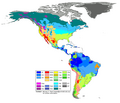
Fichier:Americas Köppen Map.png

Taille de cet aperçu : 483 × 599 pixels. Autres résolutions : 193 × 240 pixels | 387 × 480 pixels | 619 × 768 pixels | 1 096 × 1 360 pixels.
Fichier d’origine (1 096 × 1 360 pixels, taille du fichier : 520 kio, type MIME : image/png)
Historique du fichier
Cliquer sur une date et heure pour voir le fichier tel qu'il était à ce moment-là.
| Date et heure | Vignette | Dimensions | Utilisateur | Commentaire | |
|---|---|---|---|---|---|
| actuel | 20 février 2018 à 20:20 |  | 1 096 × 1 360 (520 kio) | Maphobbyist | The Costa Rican Central Valley has a dry winter oceanic climate (Köppen classification: Cwb). |
| 8 février 2018 à 01:19 |  | 1 096 × 1 360 (433 kio) | WolfmanSF | Reverted to version as of 10:48, 27 December 2008 (UTC) - the northernmost areas aren't of much interest for the purposes of the Great American Interchange article which uses this image | |
| 7 février 2018 à 22:30 |  | 1 860 × 1 593 (526 kio) | Maphobbyist | Included Alaska, Northern Canada and Greenland which were omitted. | |
| 27 décembre 2008 à 11:48 |  | 1 096 × 1 360 (433 kio) | WolfmanSF | {{Information |Description= |Source= |Date= |Author= |Permission= |other_versions= }} | |
| 21 décembre 2008 à 22:46 |  | 1 096 × 1 360 (439 kio) | WolfmanSF | rotate legend to make lettering horizontal; remove boxes for unused climate zones | |
| 5 mai 2008 à 06:21 |  | 1 096 × 1 360 (428 kio) | WolfmanSF | {{Information |Description=Updated world map of the Köppen-Geiger climate classification. |Source=[http://www.hydrol-earth-syst-sci.net/11/1633/2007/hess-11-1633-2007.html Hydrology and Earth System Sciences: "Updated world map of the Köppen-Geiger clim |
Utilisation du fichier
La page suivante utilise ce fichier :
Usage global du fichier
Les autres wikis suivants utilisent ce fichier :
- Utilisation sur az.wikipedia.org
- Utilisation sur bg.wikipedia.org
- Utilisation sur en.wikipedia.org
- Utilisation sur es.wikipedia.org
- Utilisation sur he.wikipedia.org
- Utilisation sur nl.wikipedia.org
- Utilisation sur uk.wikipedia.org
