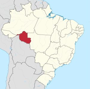
Rondônia is a state in the North of Brazil.

Cities
- 1 Porto Velho — despite the name (old port), it was only founded in 1914 and is architecturally modern
- 2 Ariquemes — hosts Expoari, the biggest rodeo party in Rondônia
- 3 Buritis — a city of 40,000 that is a service center for local farmers
- 4 Cacoal — called "the Capital of Coffee", it has waterfalls and beautiful lakes to visit
- 5 Guajará-Mirim — a free trade zone where boat tours are offered on the Mamoré and Guaporé Rivers
- 6 Jaru — a city of 52,0000 people in the Jaru River valley
- 7 Ji-Paraná — Expojipa, for 9 nights in July, is the largest agricultural fair in the North Region of Brazil
- 8 Machadinho d'Oeste — hosts the Garota Cachoeira Beach Festival and the state stage of Motocross annually
- 9 Ouro Preto do Oeste — a city of 36,000 people in 2020
- 10 Pimenta Bueno — known for hosting popular events sponsored by the Catholic church
- 11 Rolim de Moura — the main events in the city are the "Festa do Milho", a gastronomic event, and the "Feira Agropecuária de Rolim de Moura", an agricultural fair with shows, fireworks and rodeo
- 12 Vilhena — a major educational center, known for its cooler climate
Other destinations
- 1 Pacaás Novos National Park —
- 2 Serra da Cutia National Park — beautiful landscapes, diverse wildlife, and several unique species of birds
- 3 Guaporé Biological Reserve — the reserve is a three-day trip from the city of Guajará-Mirim. You can visit the ruins of the Real Forte Príncipe da Beira, built in the 18th century by Portuguese colonizers
- 4 Jaru Biological Reserve — a survey recorded 168 species of fish, the probable presence of 189 species of amphibians and reptiles, 538 species of birds and over 73 species of mammals
Understand
Rondonia used to be home to over 200,000 km² of rainforest, but has become one of the most deforested places in the Amazon due to mining and cattle herding. In 2013, the state was one of the largest exporters of beef in Brazil , with a herd of 12 million heads.
As of 2011 there were 21 Indigenous Territories in Rondônia, with two more in process of being demarcated. The largest of these, the Uru-Eu-Wau-Wau Indigenous Territory, covers over 1.8 million hectares. Another, the Rio Omerê Indigenous Territory, is home to the Kanoê and Akuntsu people. Both tribes were the victims of massacres by cattle ranchers in the 1970s and 1980s, by 2013 had only four and five individuals respectively.
Over 20 indigenous languages are spoken in Rondônia.
Get in
The BR-364, fully paved in the Rondônia section, crosses the state from the border with Mato Grosso to the border with Acre.
Governador Jorge Teixeira International Airport, in Porto Velho, is the most important in the state and receives daily flights from Brasília, Belo Horizonte, Cuiabá, Manaus and Rio Branco, from municipalities in the interior of the state of Rondônia such as Ji-Paraná and Vilhena and from interior of the Amazon, such as Lábrea and Manicoré. It also has flights from Porto Alegre, with stopovers in Curitiba , Campo Grande and Cuiabá, flights to São Paulo and Rio de Janeirowith stopovers in Brasília and Fortaleza, with a stopover in Manaus and Belém.
In the interior of the state, the three main airports are José Coleto Airport in Ji-Paraná, which has four daily flights, Brigadeiro Camarão Airport in Vilhena, and the Capital do Café Airport, in Cacoal.
Get around
To find out about road conditions, call the Federal Highway Police in the state, ☏ +55 69 3451-2333
See
Do
Porto Velho is a starting point for excursions into the Amazon.
Festivals
The Banda do Vai Quem Quer draws more than 100 000 people in the streets of Porto Velho during the Carnival festivities. Another festival of great importance is the Arraial Flor do Maracujá, held in Porto Velho in June, and which represents the strength of Northeastern culture. It is the second largest festival in Brazil.
Also in June, the Guajará-Mirim Folk Festival stands out, in which the main attractions are the performances of the bois-bumbás, an expression of the Amazonian culture in the region. To mark the immense strength of the agricultural culture , there are several rodeo parties and agricultural exhibitions in most municipalities in the state.
Expoari, held in Ariquemes in the Exhibition Park around the end of July, is the biggest rodeo in Rondônia, and one of the 5 largest rodeos in Brazil. There are nine days of event, where several musical shows take place, with artists from all over the country. Other rodeos include Expovil, in Vilhena, Expojipa, in Ji- Paraná and Expovel, in Porto Velho.
The city of Alto Paraíso holds the National Race of Jericos Motorizados every year, known as Festa do Jerico. It consists of a race of automobiles called Jericos, conceived by mechanics to adapt to work in the fields and the mistreated dirt roads that existed in the early days of the State of Rondônia, by joining parts of the different types of car.
Eat
Because Rondônia receives people from several states in Brazil, its cuisine is quite diverse. In cooking, fish and flour from the Amazon, polenta from Paraná, barbecue from Rio Grande do Sul and tereré from Mato Grosso are widely consumed. In addition, a very common snack is salteña, of Bolivian origin.

