Yanpu
Appearance
Yanpu Township 鹽埔鄉 | |
|---|---|
 | |
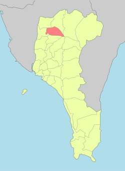
 Yanpu Township in Pingtung County | |
 | |
| Location | Pingtung County, Taiwan |
| Area | |
• Total | 64 km2 (25 sq mi) |
| Population (February 2024) | |
• Total | 23,878 |
| • Density | 370/km2 (970/sq mi) |
| Yanpu Township | |
|---|---|
| Traditional Chinese | 鹽埔鄉 |
| Hanyu Pinyin | Yánpǔ Xiāng |
| Wade–Giles | Yen2-p'u3 Hsiang1 |
| Pha̍k-fa-sṳ | Yâm-phû-hiông |
| Hokkien POJ | Iâm-po͘-hiong |
Yanpu Township[1] is a rural township in Pingtung County, Taiwan.
Geography
[edit]

- Population: 23,878 (February 2024)
- Area: 64.35 square kilometres (24.85 sq mi)
Administrative divisions
[edit]The township comprises 12 villages: Gaolang, Jiuai, Luoyang, Pengcuo, Shirong, Xiner, Xinwei, Yanbei, Yannan, Yanzhong, Yonglong and Zhenxing.
Education
[edit]References
[edit]- ^ 臺灣地區鄉鎮市區級以上行政區域名稱中英對照表 Glossary of Names for Administrative Divisions. (in Chinese) Accessed at Taiwan Geographic Names Information System website (in English). Ministry of the Interior. 16 June 2011. Retrieved 1 April 2015.
External links
[edit]Wikimedia Commons has media related to Yanpu Township, Pingtung.
- Yenpu Township Office website (in Chinese)
 Geographic data related to Yanpu at OpenStreetMap
22°45′16″N 120°34′21″E / 22.7544°N 120.5724°E

