Assinovskaya
Assinovskaya
Ассиновская | |
|---|---|
| Other transcription(s) | |
| • Chechen | Эха-Борзе |
| • Ingush | Ахь-Борза |
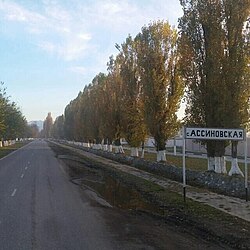
 The entrance to Assinovskaya | |
| Coordinates: 43°14′07″N 45°10′55″E / 43.23528°N 45.18194°E | |
| Country | Russia |
| Federal subject | Chechnya |
| Founded | 1847 |
| Elevation | 273 m (896 ft) |
| Population | |
• Total | 10 184 |
• Estimate (2021)[2] | 9,809 |
| • Subordinated to | Sernovodsky District |
| Time zone | UTC+3 (MSK |
| Postal code(s)[4] | |
| OKTMO ID | 96631404101 |
Assinovskaya[a] is rural locality (a stanitsa) in Sernovodsky District of the Republic of Chechnya, Russia.
Administrative and municipal status
[edit]Municipally, Assinovskaya is incorporated as Assinovskoye rural settlement. It is the administrative center of the municipality and is the only settlement included in it.[6]
Geography
[edit]
The village of Assinovskaya is located on the left bank of the Assa River (hence the name). It is located 6 kilometres (3.7 mi) south of the village of Sernovodskoye and 45 kilometres (28 mi) west of the city of Grozny.
The nearest settlements to Assinovskaya are Sernovodskoye in the north, Novy Sharoy in the east, Achkhoy-Martan in the south-east, Bamut in the south, and Berd-Yurt and Nesterovskaya in the west.[7]
History
[edit]The village of Assinovskaya was founded in 1847 on the land of the Karabulak aul of Akh-Borzoy.[8][9] According to official maps at the time, the aul and the village existed simultaneously, so on the map of the for 1871, there are the village of Assinskaya and the aul of Akhbarzoy, which is located on the opposite (right) bank of the Assa river, with Assinovskaya on the left, at the mouth of the Zheltukha stream.[10]


According to the Regulations on the management of the Terek Oblast in 1862, the Ingushskiy Okrug was established as part of the Western Department. It included societies of Nazranians, Karabulaks, Galgai, Kistins, Akkins and Tsorins[11] (also Meredzhin society and some Galanchozh and Yalkharoy auls[12]) which were ceded to Argunskiy Okrug in 1866 due to them belonging to the same nation as the locals (Chechens) and geographically closer to the central governance of the Okrug[13]). The village of Akh-Borzoy (Assinovskaya) was part of the Ingushskiy Okrug.[12]
In the summer of 1992, the church in the village was attacked. About 30 attackers broke religious items, shot at the icons and images with machine guns, and raided the altar. In 1997, the new abbot of the church was killed in another attack, and the walls of the church were burned.[14] In 2013, the rebuilding of the church was finally completed, and the building was reopened.
In 1994, the residents of the village wrote a letter to the former President of the Russian Federation, Boris Yeltsin, with a plea for help, and explaining the facts of robbery, kidnapping and murder against ethnic Russian residents of the village.[15] On 28 March 1999 and 8 April 1999, two Orthodox priests in the village were kidnapped. Peter Sukhonosov, the Archpriest, was killed, and priest Sergey Potapov was released.[16]
In 2003, the village of Assinovskaya, together with Sernovodskoye, were transferred to Chechnya.
Population
[edit]- 1939 Census: 6,004
- 1959 Census: 7,314
- 1970 Census: 7,492
- 1979 Census: 7,020
- 1990 Census: 6,969
- 2002 Census: 10,248[17]
- 2010 Census: 10,184[18]
- 2019 estimate: 10,992
According to the 2010 Census, the majority of residents of Assinovskaya (10,058 or 98.76%) were ethnic Chechens, with 126 people (1.24%) coming from other ethnic backgrounds.
Notes
[edit]References
[edit]- ^ Russian Federal State Statistics Service (2011). Всероссийская перепись населения 2010 года. Том 1 [2010 All-Russian Population Census, vol. 1]. Всероссийская перепись населения 2010 года [2010 All-Russia Population Census] (in Russian). Federal State Statistics Service.
- ^ "Таблица 5. Численность населения России, федеральных округов, субъектов Российской Федерации, городских округов, муниципальных районов, муниципальных округов, городских и сельских поселений, городских населенных пунктов, сельских населенных пунктов с населением 3000 человек и более". Всероссийской переписи населения 2020 года[permanent dead link]
- ^ "Об исчислении времени". Официальный интернет-портал правовой информации (in Russian). 3 June 2011. Retrieved 19 January 2019.
- ^ Почта России. Информационно-вычислительный центр ОАСУ РПО. (Russian Post). Поиск объектов почтовой связи (Postal Objects Search) (in Russian)
- ^ "Ярташ". "Даймохк" газет (in Russian).
- ^ "Сельское поселение Ассиновское (Чеченская Республика)". www.bankgorodov.com.
- ^ "Карта Чеченской республики подробная с районами, селами и городами. Схема и спутник онлайн". 1maps.ru. 28 March 2024.
- ^ "МЫЧКИЗЫ". www.vostlit.info.
- ^ "Владикавказские епархиальные ведомости Г. 10 1904, № 15" (in Russian). 1904.
- ^ "Карта Стрельбицкого. Кавказ". www.etomesto.ru.
- ^ Сборник документов и материалов 2020, pp. 255–257.
- ^ a b Сборник статистических сведений о Кавказе 1869, p. 45.
- ^ "НЭБ - Национальная электронная библиотека".
- ^ "Юрий Сошин. Православие и Кавказ. Кавказская война это война за души, и выигрыв". old.memo.ru. Archived from the original on 2018-04-07. Retrieved 2019-09-20.
- ^ "assinovskaya". www.left.ru.
- ^ "Освобождены двое священнослужителей, удерживавшихся в заложниках в Ингушетии | Православная газета". orthodox-newspaper.ru.
- ^ Kashnitsky, Ilya (11 April 2017). "Municipality level Russian Census data 2002 and 2010". doi:10.17605/OSF.IO/CSKMU.
{{cite journal}}: Cite journal requires|journal=(help) - ^ "ВПН-2010". www.gks.ru.
Bibliography
[edit]- Ингушетия в политике Российской империи на Кавказе. XIX век. Сборник документов и материалов (in Russian). Ростов-на-Дону: Южный издательский дом. 2020. pp. 1–760. ISBN 978-5-98864-060-8.
- Список горских аулов Кубанской и Терской областей / Сборник статистических сведений о Кавказе / Сост. и ред. Н. И. Воронов, Кавказский отдел Императорского русского географического общества (in Russian). Тифлис: Типография Главного Управления Наместника Кавказского; типогрфия Меликова и К. 1869. pp. 41—52 (418—429 PDF).


