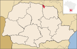
Sertaneja, Paraná
Tools
Actions
General
Print/export
In other projects
Appearance
From Wikipedia, the free encyclopedia
The printable version is no longer supported and may have rendering errors. Please update your browser bookmarks and please use the default browser print function instead.
This article is about the municipality in Paraná state. For the music genre, see Música sertaneja. For other uses, see Sertaneja (disambiguation).
Place in Brazil
Sertaneja | |
|---|---|
 Location in Brazil | |
| Coordinates: 23°02′13″S 50°50′16″W / 23.03694°S 50.83778°W / -23.03694; -50.83778 | |
| Country | Brazil |
| State | Paraná |
| Area | |
| • Total | 444.48 km2 (171.61 sq mi) |
| Elevation | 520 m (1,710 ft) |
| Population (2020 [1]) | |
| • Total | 5,216 |
| Time zone | UTC−3 (BRT) |
| Website | sertaneja.pr.gov.br |
Sertaneja is a municipality in the state of Paraná in Brazil.
It was established as a municipality according to Law nº 2/1947, dated 10 October 1947 dividing the earlier Cornélio Procópio municipality into 3 new district municipalities: Sertaneja, Leópolis and Congonhas.
The municipal area of Sertaneja is 444,48 km² and its population 5,216 (2020). Agriculture is the town's main industry.[2]
References
This article needs additional citations for verification. Please help improve this article by adding citations to reliable sources. Unsourced material may be challenged and removed. Find sources: "Sertaneja, Paraná" – news · newspapers · books · scholar · JSTOR (January 2021) (Learn how and when to remove this message) |
- ^ IBGE 2020
- ^ "Sertaneja". VIAJE PARANÁ (in Brazilian Portuguese). Retrieved 2024-07-25.
Hidden categories:


