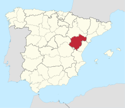
Teruel (Catalan: Terol [təˈɾɔl]) is a province of Aragon, in the northeast of Spain. The capital is Teruel.
Teruel Province | |
|---|---|
 The Sierra Carrascosa with the Guerrero Romano rock formation near Bordón | |
 Map of Spain with Teruel Province highlighted | |
| Coordinates: 40°40′N 0°40′W / 40.667°N 0.667°W | |
| Country | |
| Autonomous community | |
| Capital | Teruel |
| Area | |
| • Total | 14,809 km2 (5,718 sq mi) |
| • Rank | Ranked 10th |
| 2.93% of Spain | |
| Population (2018) | |
| • Total | 134,572 |
| • Rank | Ranked 49th |
| • Density | 9.1/km2 (24/sq mi) |
| Demonym | Turolense |
It is bordered by the provinces of Tarragona, Castellón, Valencia (including its exclave Rincón de Ademuz), Cuenca, Guadalajara, and Zaragoza. The area of the province is 14,809 km². Its population is 134,572 (2018), of whom about a quarter live in the capital, and its population density is 9.36/km². It contains 236 municipalities, of which more than half are villages of under 200 people. Teruel is the second-least populated province of Spain, and also the second-lowest in population density, in both counts after the province of Soria.
The main language throughout the province is Spanish (with official status), although Catalan is spoken in a northeastern area bordering Catalonia.
Geography
editThis province is located in the mountainous Sistema Ibérico area. The main ranges in the province of Teruel are Sierra de la Virgen, Sierra de Santa Cruz, Sierra de Cucalón, Sierra de San Just, Sierra Carrascosa, Sierra Menera, Sierra Palomera, Sierra de Javalambre, Sierra de Gúdar, Sierra de Albarracín and the Montes Universales, among others.
Depopulation and neglect
editMost of the Teruel Province has undergone massive depopulation since the middle of the 20th century. This situation is shared with other areas in Spain, particularly with those near the Iberian mountain range (much of the provinces of Soria, Guadalajara and Cuenca) and with other areas in Aragón.
The exodus from the rural mountain areas in Teruel rose after General Franco's Plan de Estabilización in 1959. The population declined steeply as people migrated towards the industrial areas and the large cities in Spain, leaving behind their small villages where living conditions were often harsh, with cold winters and very basic facilities.
As a consequence there are many ghost towns in different parts of the province.[1]
A great number of surviving towns in Teruel province have only a residual population, reviving somewhat during the summer when a few city-dwellers spend their holidays there. Other causes of the strong emigration have been the low productivity of traditional agricultural practices, like sheep and goat farming, the closing of mines, like the large Sierra Menera mine near Ojos Negros,[2] as well as the lifestyle changes that swept over rural Spain during the second half of the 20th century.[3]
The "Teruel Exists" (Spanish: Teruel existe) movement began at the turn of the 21st century. It is a platform of provincial authorities, institutions and sympathizers seeking to reverse the long-standing neglect of this province.[4]
Population development
editThe historical population is given in the following chart:

Comarcas
editThe following Comarcas of Aragon are located in Teruel Province:
Notable people
edit- Luis Buñuel, film director from Calanda
- Gaspar Sanz, music composer from Calanda
- Antón García Abril, music composer
- Pablo Serrano, sculptor from Crivillén
- Luis Milla, retired footballer who played for CD Teruel, FC Barcelona and R. Madrid
- David Civera, light music singer
- Federico Jiménez Losantos, author, journalist and radio host
- Manuel Pizarro Moreno, businessman, politician and jurist
See also
editNotes and references
edit- ^ Pueblos deshabitados – Collado de la Grulla (Teruel)
- ^ La Compañía Minera de Sierra Menera. Breve historia Archived 23 March 2012 at the Wayback Machine
- ^ Despoblación en Aragon Archived 23 August 2012 at the Wayback Machine
- ^ Teruel existe
External links
edit- Teruel.org
- Teruel Info. – Caciquismo & desarrollismo – N.B. This text-only website is in Japanese. Content not clear.
- Teruel Digital
- Directory in dmoz.org
- Fundación Amantes de Teruel
- Estado de los embalses de Teruel
- Teruel.com – Tourism
- Deteruel.com — Comunidad virtual de Teruel
- El número de ancianos españoles aumenta un 20% en 13 años

