Tecpan de Galeana (for Hermenegildo Galeana)[1] is a municipality in the Mexican state of Guerrero. The municipal seat lies at Tecpan de Galeana. The municipality covers an area of 2,537.8 km2 (979.9 sq mi).
Tecpan de Galeana | |
|---|---|
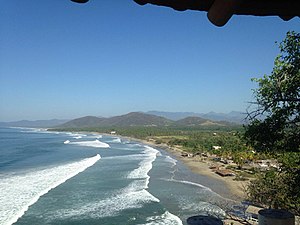
 Playa Cayaquitos in Tecpan | |
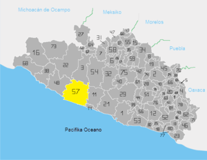
 Location of the municipality in the state | |
| Coordinates: 17°07′N 100°28′W / 17.117°N 100.467°W | |
| Country | |
| State | Guerrero |
| Municipal seat | Tecpan de Galeana |
| Area | |
| • Total | 2,537.8 km2 (979.9 sq mi) |
| Population (2005) | |
| • Total | 52,848 |
| Time zone | UTC-6 (Central) |
| Postal code | 40900 |
| Area code | 742 |
| Website | ayuntamientotecpan |
In 2020, the municipality had a total population of 65,237,[2] up from 52,848 in 2005.[3]
See also
edit- Hurricane Tara (1961), which caused extensive damage in the municipality
- Mexican Federal Highway 200, on which Tecpan stands
References
edit- ^ "Plan Municipal de Desarrollo Tecpan de Galeana 2021–2024" (PDF). Retrieved 31 October 2023.
- ^ "Tecpan de Galeana: Economy, employment, equity, quality of life, education, health and public safety". Secretariat of the Economy. Retrieved 31 October 2023.
- ^ "Tecpán de Galeana". Enciclopedia de los Municipios de México. Instituto Nacional para el Federalismo y el Desarrollo Municipal. Archived from the original on 17 June 2011. Retrieved 23 December 2008.


