File talk:Serbia02.png
Jump to navigation
Jump to search
problems with this map
[edit]There are many problems with this map: Mladifilozof (talk) 20:13, 10 January 2010 (UTC)
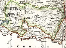
One of the sources
[edit]
- Regarding this "Wojwodowena und Banat" map, I already showed to you two other maps where name of the province is only "Vojvodina" or only "Banat": http://lib.utexas.edu/maps/historical/balkans_1859.jpg and http://feefhs.org/maplibrary/austro-hungary/banat.jpg - so, how exactly that fit with what you claim to be "original map"? PANONIAN (talk) 21:00, 10 January 2010 (UTC)
- Also, this "Wojwodowena und Banat" map that you presented as "original" in fact has no source of its origin, we do not know who made that map and when, so it is completelly questionable and disputed source for anything. PANONIAN (talk) 10:55, 11 January 2010 (UTC)
Name
[edit]- misleading name of the file Mladifilozof (talk) 20:13, 10 January 2010 (UTC)
- What you consider misleading there? PANONIAN (talk) 20:34, 10 January 2010 (UTC)
Incorrect description
[edit]- incorect description (two autonomous historical territories "named Serbia"; name of Austrian province was not Serbia, it has only word Serbia, among others, in its name) Mladifilozof (talk) 20:13, 10 January 2010 (UTC)
- If something had name "Serbia" then it was Serbia. In fact usage of name "Serbia" (in the form "Rascia") for Vojvodina is much older and goes back to the 16th century: http://kodeks.uni-bamberg.de/Hungary/media/RasciaMedieval.jpg PANONIAN (talk) 21:11, 10 January 2010 (UTC)
Southern and northern serbia
[edit]- its widespread misleading usage under the name Southern and Northern Serbia:
- If two territories had name "Serbia" and if one was in the south and another one in the north, which description you would use? PANONIAN (talk) 21:14, 10 January 2010 (UTC)
disputed name
[edit]- dusputed name of the Austrian province (see en:Talk:Voivodeship of Serbia and Banat of Temeschwar) Mladifilozof (talk) 20:13, 10 January 2010 (UTC)
colours
[edit]- choice of colors and perspective, which left room for misleading interpretation or confusion. Mladifilozof (talk) 20:13, 10 January 2010 (UTC)
- In which way? Please elaborate that... PANONIAN (talk) 20:34, 10 January 2010 (UTC)
Title position
[edit]- the position of he title. Serbian Vojvodina should be located on the left, according the position of former province Serbian Vojvodina. The title Banat of Temeswar should be located on the right, according the position of former province Banat of Temeswar, just like on the original map. Mladifilozof (talk) 20:13, 10 January 2010 (UTC)
- Ok, did I gave you answer to this already? It was a single province with long double name, not a federation of two terrirories, but one single teritory divided into districts, see this: http://sr.wikipedia.org/wiki/Војводство_Србија#.D0.A3.D0.BF.D1.80.D0.B0.D0.B2.D0.BD.D0.B0_.D0.BF.D0.BE.D0.B4.D0.B5.D0.BB.D0.B0 - there is no logical reason that we separate name of one unique territory into two parts when territory itself was not divided into two parts. These two former provinces that you mentioned existed in ANOTHER PART OF HISTORY, not in 1849-1860 and we cannot mix historical periods like that. Also map that you mentioned as "original" is "original" to what? There are many historical maps regarding this subject and I do not see that "Wojwodowena und Banat" is original in any way - we even do not know who made that map and when. PANONIAN (talk) 21:20, 10 January 2010 (UTC) PANONIAN (talk) 20:34, 10 January 2010 (UTC)
usage
[edit]Until the dispute is resolved, usage of original map is recommended.Mladifilozof (talk) 20:13, 10 January 2010 (UTC)
- "Wojwodowena und Banat" map that you call "original" is not very accurate - it has wrong borders, names of the cities are hard to read and we even do not know from which source it came. In another words, such map is very disputed piece of work. PANONIAN (talk) 20:34, 10 January 2010 (UTC)