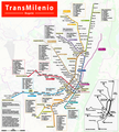
File:TransMilenio Bogota Map.png

Size of this preview: 541 × 599 pixels. Other resolutions: 217 × 240 pixels | 433 × 480 pixels | 694 × 768 pixels | 925 × 1,024 pixels | 1,849 × 2,048 pixels | 2,916 × 3,229 pixels.
Original file (2,916 × 3,229 pixels, file size: 7.29 MB, MIME type: image/png)
File information
Structured data
Captions
Captions
Add a one-line explanation of what this file represents
| DescriptionTransMilenio Bogota Map.png |
|
| Date | see file history |
| Source | Own work, using OpenStreetMap data for the background |
| Author | Maximilian Dörrbecker (Chumwa) |
| Permission (Reusing this file) |
All OpenStreetMap data and maps are Creative Commons "CC-BY-SA 2.0" licensed This file is licensed under the Creative Commons Attribution-Share Alike 2.0 Generic license.
|
File history
Click on a date/time to view the file as it appeared at that time.
| Date/Time | Thumbnail | Dimensions | User | Comment | |
|---|---|---|---|---|---|
| current | 07:23, 21 December 2019 |  | 2,916 × 3,229 (7.29 MB) | Chumwa (talk | contribs) | Américas Carrera 53 A is now called Distrito Graffiti. |
| 17:50, 5 August 2019 |  | 2,916 × 3,229 (7.29 MB) | Chumwa (talk | contribs) | corr | |
| 21:43, 20 May 2019 |  | 2,916 × 3,229 (7.29 MB) | Chumwa (talk | contribs) | update | |
| 06:39, 2 November 2018 |  | 2,916 × 3,229 (7.32 MB) | Chumwa (talk | contribs) | corr | |
| 20:06, 30 October 2018 |  | 2,916 × 3,229 (7.32 MB) | Chumwa (talk | contribs) | update | |
| 20:07, 2 April 2018 |  | 2,916 × 3,229 (7.32 MB) | Chumwa (talk | contribs) | some amendments | |
| 21:05, 16 September 2017 |  | 2,916 × 3,229 (7.38 MB) | Chumwa (talk | contribs) | added Route 14-2 | |
| 06:58, 15 September 2017 |  | 2,916 × 3,229 (7.38 MB) | Chumwa (talk | contribs) | update of the servicios corrientes | |
| 07:44, 7 May 2017 |  | 2,916 × 3,229 (7.4 MB) | Chumwa (talk | contribs) | ||
| 07:07, 29 April 2017 |  | 2,916 × 3,229 (7.4 MB) | Chumwa (talk | contribs) |
You cannot overwrite this file.
File usage on Commons
The following 40 pages use this file:
- Bogotá
- User:Chumwa/Gallery
- User:Chumwa/OgreBot/Potential transport maps/2017 April 21-30
- User:Chumwa/OgreBot/Potential transport maps/2017 May 1-10
- User:Chumwa/OgreBot/Potential transport maps/2017 September 11-20
- User:Chumwa/OgreBot/Potential transport maps/2018 April 1-10
- User:Chumwa/OgreBot/Potential transport maps/2018 November 1-10
- User:Chumwa/OgreBot/Potential transport maps/2018 October 21-31
- User:Chumwa/OgreBot/Potential transport maps/2019 August 1-10
- User:Chumwa/OgreBot/Potential transport maps/2019 December 21-31
- User:Chumwa/OgreBot/Potential transport maps/2019 May 11-20
- User:Chumwa/OgreBot/Public transport information/2017 April 21-30
- User:Chumwa/OgreBot/Public transport information/2017 May 1-10
- User:Chumwa/OgreBot/Public transport information/2017 September 11-20
- User:Chumwa/OgreBot/Public transport information/2018 April 1-10
- User:Chumwa/OgreBot/Public transport information/2018 November 1-10
- User:Chumwa/OgreBot/Public transport information/2018 October 21-31
- User:Chumwa/OgreBot/Public transport information/2019 August 1-10
- User:Chumwa/OgreBot/Public transport information/2019 December 21-31
- User:Chumwa/OgreBot/Public transport information/2019 May 11-20
- User:Chumwa/OgreBot/Transport Maps/2017 April 21-30
- User:Chumwa/OgreBot/Transport Maps/2017 May 1-10
- User:Chumwa/OgreBot/Transport Maps/2017 September 11-20
- User:Chumwa/OgreBot/Transport Maps/2018 April 1-10
- User:Chumwa/OgreBot/Transport Maps/2018 November 1-10
- User:Chumwa/OgreBot/Transport Maps/2018 October 21-31
- User:Chumwa/OgreBot/Transport Maps/2019 August 1-10
- User:Chumwa/OgreBot/Transport Maps/2019 December 21-31
- User:Chumwa/OgreBot/Transport Maps/2019 May 11-20
- User:Chumwa/OgreBot/Travel and communication maps/2017 April 21-30
- User:Chumwa/OgreBot/Travel and communication maps/2017 May 1-10
- User:Chumwa/OgreBot/Travel and communication maps/2017 September 11-20
- User:Chumwa/OgreBot/Travel and communication maps/2018 April 1-10
- User:Chumwa/OgreBot/Travel and communication maps/2018 November 1-10
- User:Chumwa/OgreBot/Travel and communication maps/2018 October 21-31
- User:Chumwa/OgreBot/Travel and communication maps/2019 August 1-10
- User:Chumwa/OgreBot/Travel and communication maps/2019 December 21-31
- User:Chumwa/OgreBot/Travel and communication maps/2019 May 11-20
- Commons:Files used on the OpenStreetMap Wiki/42
- Category:TransMilenio
File usage on other wikis
The following other wikis use this file:
- Usage on bn.wikivoyage.org
- Usage on ca.wikipedia.org
- Usage on de.wikipedia.org
- Usage on de.wikivoyage.org
- Usage on en.wikipedia.org
- Usage on en.wikibooks.org
- Usage on en.wikivoyage.org
- Usage on es.wikipedia.org
- Usage on fa.wikivoyage.org
- Usage on fr.wikipedia.org
- Usage on gd.wikipedia.org
- Usage on he.wikivoyage.org
- Usage on id.wikipedia.org
- Usage on it.wikipedia.org
- Usage on it.wikivoyage.org
- Usage on ja.wikipedia.org
- Usage on no.wikipedia.org
- Usage on pl.wikivoyage.org
- Usage on pt.wikipedia.org
- Usage on vi.wikipedia.org
- Usage on www.wikidata.org
Metadata
This file contains additional information such as Exif metadata which may have been added by the digital camera, scanner, or software program used to create or digitize it. If the file has been modified from its original state, some details such as the timestamp may not fully reflect those of the original file. The timestamp is only as accurate as the clock in the camera, and it may be completely wrong.
| Horizontal resolution | 78.74 dpc |
|---|---|
| Vertical resolution | 78.74 dpc |
| Software used |