File:NowaMapaS3.svg

Size of this PNG preview of this SVG file: 643 × 599 pixels. Other resolutions: 258 × 240 pixels | 515 × 480 pixels | 824 × 768 pixels | 1,099 × 1,024 pixels | 2,198 × 2,048 pixels | 776 × 723 pixels.
Original file (SVG file, nominally 776 × 723 pixels, file size: 187 KB)
Captions
Captions
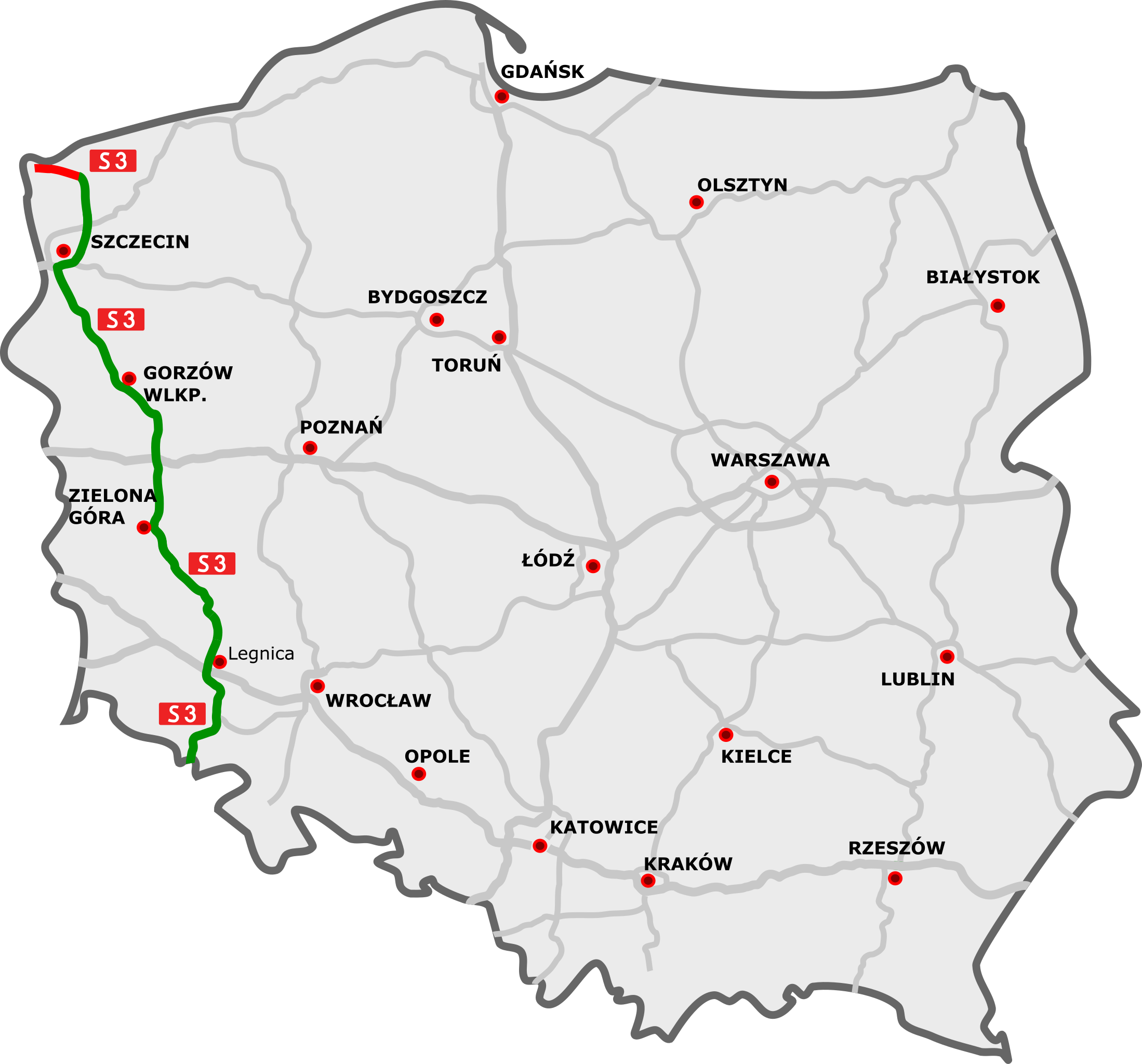
S3 Expressway on the map of Poland
Any autoconfirmed user can overwrite this file from the same source. Please ensure that overwrites comply with the guideline.
| Description | |
| Date | |
| Source |
|
| Author |
|
| This is a retouched picture, which means that it has been digitally altered from its original version. Modifications: S3. The original can be viewed here: DocelowyUkladDrog.svg:
|
I, the copyright holder of this work, hereby publish it under the following license:
This file is licensed under the Creative Commons Attribution 3.0 Unported license.
- You are free:
- to share – to copy, distribute and transmit the work
- to remix – to adapt the work
- Under the following conditions:
- attribution – You must give appropriate credit, provide a link to the license, and indicate if changes were made. You may do so in any reasonable manner, but not in any way that suggests the licensor endorses you or your use.
Original upload log
edit
This image is a derivative work of the following images:
- File:DocelowyUkladDrog.svg licensed with Cc-by-3.0
- 2009-09-22T16:31:17Z Sliwers 784x723 (153828 Bytes) Zgorzelec/Jędrzychowice
- 2009-08-31T18:21:25Z Sliwers 784x723 (153823 Bytes) Colors
- 2009-08-30T16:41:32Z Sliwers 784x723 (155471 Bytes) Darker color.
- 2009-08-30T16:40:18Z Sliwers 784x723 (155471 Bytes) Cropped.
- 2009-08-30T16:36:58Z Sliwers 1073x790 (154212 Bytes) {{Information |Description={{en|1=Map of the planned free- and expressway network in Poland.}} {{pl|1=Docelowy układ autostrad i dróg ekspresowych w Polsce.}} {{de|1=Das Autobahn- und Schnellstraßennetz Polens, geplanter E
Uploaded with derivativeFX
File history
Click on a date/time to view the file as it appeared at that time.
| Date/Time | Thumbnail | Dimensions | User | Comment | |
|---|---|---|---|---|---|
| 20:39, 19 December 2010 |  | 785 × 724 (93 KB) | Sliwers (talk | contribs) | Corrected path and background | |
| 07:32, 23 October 2010 |  | 784 × 723 (71 KB) | Sliwers (talk | contribs) | New section open: Pyrzyce - Myślibórz | |
| 15:24, 10 October 2010 |  | 784 × 723 (71 KB) | Sliwers (talk | contribs) | Small correction | |
| 15:18, 10 October 2010 |  | 784 × 723 (71 KB) | Sliwers (talk | contribs) | Added expressways | |
| 20:18, 23 July 2010 |  | 784 × 723 (52 KB) | Sliwers (talk | contribs) | New section under construction (Międzyrzecz - Sulechów) | |
| 18:42, 28 May 2010 |  | 784 × 723 (51 KB) | Sliwers (talk | contribs) | Two sections under construction north from Szczecin. | |
| 18:06, 28 May 2010 |  | 784 × 723 (51 KB) | Sliwers (talk | contribs) | New section (Szczecin - Pyrzyce) open. | |
| 20:50, 29 December 2009 |  | 784 × 723 (49 KB) | Sliwers (talk | contribs) | S3/S6 fix | |
| 19:16, 23 October 2009 |  | 784 × 723 (48 KB) | Sliwers (talk | contribs) | Removed one, tiny artifact | |
| 18:57, 22 October 2009 |  | 784 × 723 (49 KB) | Sliwers (talk | contribs) | {{Information |Description={{pl}}Przebieg drogi S8: {{Legend||line=7px solid #009100|odcinki istniejące}} {{Legend||line=7px solid red|odcinki w budowie}} {{Legend||line=7px dotted #444444|odcinki projektowane}} {{en |
You cannot overwrite this file.
File usage on Commons
The following 24 pages use this file:
- User:Chumwa/OgreBot/Potential transport maps/2017 October 11-20
- User:Chumwa/OgreBot/Potential transport maps/2018 May 21-31
- User:Chumwa/OgreBot/Potential transport maps/2019 December 21-31
- User:Chumwa/OgreBot/Potential transport maps/2019 May 21-31
- User:Chumwa/OgreBot/Transport Maps/2015 December 21-31
- User:Chumwa/OgreBot/Transport Maps/2015 March 11-20
- User:Chumwa/OgreBot/Transport Maps/2015 October 21-31
- User:Chumwa/OgreBot/Transport Maps/2017 October 11-20
- User:Chumwa/OgreBot/Transport Maps/2018 May 21-31
- User:Chumwa/OgreBot/Transport Maps/2019 December 21-31
- User:Chumwa/OgreBot/Transport Maps/2019 May 21-31
- User:Chumwa/OgreBot/Transport Maps/2021 December 21-31
- User:Chumwa/OgreBot/Transport Maps/2022 September 21-30
- User:Chumwa/OgreBot/Transport Maps/2024 August 1-10
- User:Chumwa/OgreBot/Travel and communication maps/2017 October 11-20
- User:Chumwa/OgreBot/Travel and communication maps/2018 May 21-31
- User:Chumwa/OgreBot/Travel and communication maps/2019 December 21-31
- User:Chumwa/OgreBot/Travel and communication maps/2019 May 21-31
- User:Chumwa/OgreBot/Travel and communication maps/2021 December 21-31
- User:Chumwa/OgreBot/Travel and communication maps/2022 September 21-30
- User:Chumwa/OgreBot/Travel and communication maps/2024 August 1-10
- User:Sliwers
- Commons:Files used on the AARoads Wiki/89
- Category:Expressway S3 (Poland)
File usage on other wikis
The following other wikis use this file:
- Usage on cs.wikipedia.org
- Usage on de.wikipedia.org
- Usage on en.wikipedia.org
- Usage on eo.wikipedia.org
- Usage on fr.wikipedia.org
- Usage on hu.wikipedia.org
- Usage on it.wikipedia.org
- Usage on ja.wikipedia.org
- Usage on lmo.wikipedia.org
- Usage on lv.wikipedia.org
- Usage on pl.wikipedia.org
- Usage on ro.wikipedia.org
- Usage on uk.wikipedia.org
- Usage on vi.wikipedia.org
- Usage on www.wikidata.org